

Introduction
On 12 October 2021, The International Court of Justice (“ICJ or Court”) issued its decision in the case of Maritime Delimitation in the Indian Ocean (Somalia v. Kenya). The dispute concerned the establishment of the single maritime boundary between Somalia and Kenya (the Parties) in the Indian Ocean. Somalia asked the ICJ to determine, on the basis of international law, a single maritime boundary dividing all the maritime areas concerning Somalia and Kenya in the Indian Ocean.
The decision heralds the consistency in jurisprudence and methodology pertinent to delimitation of maritime boundaries. In this case, the ICJ ruled in favor of Somalia, albeit partially, where it rejected its arguments seeking that Kenya had violated its international obligations through its maritime activities including seismic testing and drilling in the disputed area. A useful primer on the salient features of the judgment can be found here. It is interesting to note that out of fifteen judges of the Court, six rendered separate opinions.
This piece attempts to analyze the three-stage test applied by the ICJ in arriving at an equitable single maritime boundary between Somalia and Kenya. While doing so, the article discusses the background of the dispute and the applicable international law principles and substantive sources concerning delimitation of maritime boundaries.
Background to the Dispute
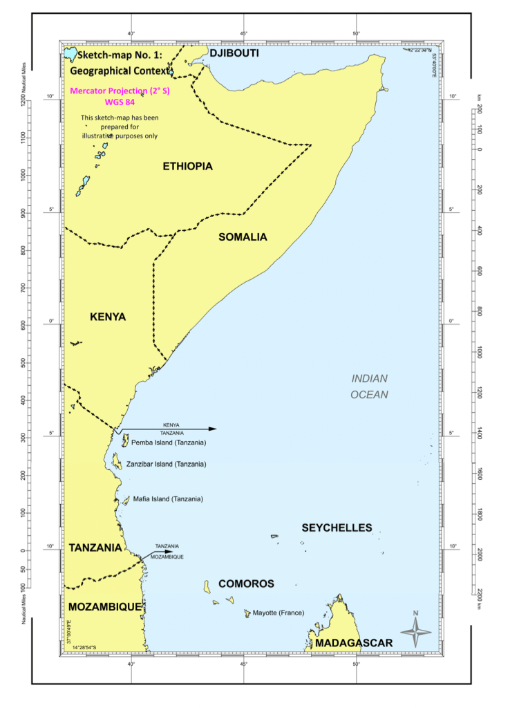
Before discussing the nuances of the case, a short contextual primer may be useful. Somalia and Kenya are adjacent States on the coast of East Africa (depicted below).
In 1924, Italy and the United Kingdom concluded a treaty regulating the boundaries of their respective territories in East Africa, including the Italian colony of Jubaland, located in present-day Somalia, and the British colony of Kenya. Following this, the parties via an Exchange of Notes of 1933 between the British and Italian Governments concluded the so-called “1927/1933 treaty arrangement”. After independence, both countries became members of the United Nations Convention on the Law of Sea (“UNCLOS”).
In 2009, the executive organs of both states reached a Memorandum of Understanding (“MoU”) where the two States agreed to delimit their maritime boundary by negotiations. However, the Somalian Parliament later rejected the MoU. Moreover, the situation was further aggravated in 2012 when Kenya awarded exploration licenses for eight offshore blocks in the Indian Ocean to foreign oil companies. This action prompted an outcry from Somalia. Somalia asserted that Kenya had contravened Somalia’s Law No. 37 (which defined Somalia’s continental shelf and EEZ).
On 28 August 2014, Somalia filed in the Registry of the ICJ instituting proceedings against Kenya. In its judgment on preliminary objections on 2 February 2017, the Court rejected the preliminary objections raised by Kenya, and found that it had jurisdiction to entertain the Application filed by Somalia and that the Application was admissible. Kenya did not participate in those hearings (discussed here).
Contentions of the Parties
In brief, both parties vastly differed in their adopted methodology to the delimitation of maritime areas. Somalia argued that no maritime boundary existed between the two States and asked the ICJ to plot a boundary line using the equidistance/special circumstances method and the equidistance/relevant circumstances method for the maritime areas beyond the territorial sea (para. 35). In its view, Somalia asserted that an unadjusted equidistance line throughout all maritime areas achieves the equitable result required by international law. Somalia argued that Kenya had violated its international obligations by its conduct in the disputed area and accordingly demanded full reparation (para.198).
Nonetheless, Kenya contended that there already existed an agreed maritime boundary between the States since Somalia had acquiesced or tacitly agreed to a boundary that follows the parallel of latitude at 1° 39′ 43.2″ S (the parallel of latitude) (para. 37). Further, it contended that the Parties have considered the parallel of latitude to be an equitable delimitation, considering both the geographical context and regional practice (See below).

Applicable Law and Ruling
For the first time, in the North Sea Continental Shelf cases, the ICJ pronounced the applicable principles and rules of international law for the delimitation of continental shelf. To overcome the distorting effect caused by irregular situations such as convex or concave shaped coastlines, the ICJ held that the act of delimitation needed balancing by importing equitable principles to bring about proportionality in delimiting maritime boundaries. Further, both Kenya and Somalia were parties to the UNCLOS. Accordingly, UNCLOS provisions were applicable in determining the maritime boundaries between them.
In its judgment, after considerable discussion, the Court decreed that Kenya had not violated its international obligations through its maritime activities in the disputed area. Since Kenya’s international responsibility was not engaged, the question of reparation did not arise.
On the point of delimitation, the Court carefully set out the delimitation methodology and jurisprudence developed by it since the adoption of UNCLOS. While charting the maritime delimitation line, the Court proceeded in three stages, which it had precisely delineated in the case concerning Maritime Delimitation in the Black Sea (Romania v. Ukraine). The three-stage methodology for maritime delimitation has also been applied by numerous arbitration tribunals. The methodology involved three steps discussed in detail in the next segment – namely, establishing a provisional equidistance line, assessing whether there is a need to adjust this determined line, and subjecting the said line to a disproportionality test.
The 3-Stage Methodology
Establishing a provisional equidistance line
This step entails that the Court must identify the appropriate base points on the coasts of the parties. The Court had specified in Romania v. Ukraine that “the line is plotted on strictly geometrical criteria on the basis of objective data” (para. 123). It further clarified that in the identification of base points of the equidistant line, the Court will have regard to the proposals of the parties, but it need not select a particular base point, despite an agreement between the parties, if it does not consider that base point to be appropriate. Therefore, the Court may select a base point that neither party has proposed.
Moreover, in consistency with earlier pronouncements, the Court observed that it “has sometimes been led to eliminate the disproportionate effect of small islands” (para. 111), by not selecting a base point on such small maritime features such as islets or rocks, which may adversely affect an equitable solution. In light of this, the appropriate base points for the median line was made solely on solid land on the mainland coasts of the Parties. The Court declined to place base points on the tiny arid Diua Damasciaca islets and Ras Kambooni which would have a disproportionate impact on the course of the median line in comparison to the size of these features.
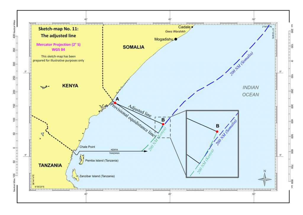
On this basis, the Court charted the equidistance line for the territorial sea. Then, by using this line and the base points, it projected the equidistance line to the exclusive economic zone and the continental shelf within 200 nautical miles. It also precisely circumscribed the relevant coast and area for the purposes of the dispute (see below the provisional equidistance line prepared by the Court).

Whether there is a need to adjust the provisional equidistance line
In this step, the Court considered whether there are factors calling for the adjustment or shifting of the provisional equidistance line in order to achieve an equitable result. Various factors, called “relevant circumstances”, may induce the readjustment or shifting of the provisional line. Kenya argued that the provisional equidistance line was inequitable while Somalia saw no plausible reason for adjusting the line and believed that it would constitute an equitable boundary. If the line is perceived to be inequitable, then the Court should adjust the line in order to achieve an equitable solution under UNCLOS.
After duly considering the relevant factors identified by Kenya and finding that the provisional equidistance line between Somalia and Kenya progressively narrows the coastal projection of Kenya. This cut-off effect occurred because of the coastline extending from Somalia to Tanzania, independently of the boundary line agreed between Kenya and Tanzania, which in fact mitigates that effect in the south, in the exclusive economic zone and on the continental shelf up to 200 nautical miles.
Therefore, the Court shifted the line to the north from Point A to mitigate the cut-off effect produced by the unadjusted equidistance line due to the geographical configuration of the coasts of Somalia, Kenya and Tanzania. The resulting line finished at an intersection with the 200-nautical-mile limit from the coast of Kenya, at Point B with co-ordinates 3° 4′ 21.3″ S and 44° 35′ 30.7″ E (see sketch-map below).
Disproportionality Test
In the third stage, the Court subjected the envisaged adjusted line to the disproportionality test. The purpose of this test is to assure the Court that there is no marked disproportion between the ratio of the lengths of the relevant coasts of the parties and the ratio of the respective shares of the parties in the relevant area to be delimited by the envisaged line.
While deliberating, the Court considered the relevant coasts of Somalia (733 km) and Kenya (511 km). The ratio of the relevant coasts came to 1:1.43 in favor of Somalia. Thus, 120,455 sq km would concern Kenya and the remaining part measuring approximately 92,389 sq km would pertain to Somalia. While the ratio between the maritime zones that would relate respectively to Kenya and Somalia was 1:1.30 in favor of Kenya. A comparison of these two ratios did not reveal any significant or marked disproportionality.
With this, the Court decided that the adjusted line had clearly established the maritime boundary for the exclusive economic zones and the continental shelves of Somalia and Kenya within 200 nautical miles in the Indian Ocean through an equitable solution as required by Article 74 and Article 83 of UNCLOS (see below).

Concluding Remarks
While being consistent with earlier jurisprudence, this delimitation reinforces an established practice towards delimiting maritime boundaries. The Court tactfully handled the delimitation by suitably applying objective principles while allowing inroads of equitable solutions. Considering the practical factors considered by the Court, the doctrinal position of delimitation of maritime boundaries under international law has become more lucid. This delimitation significantly contributes to the regional dynamics between Somalia and Kenya, which has far-reaching implications on the ownership and exploitation of maritime resources.
Adhiraj Lath is a student at Dharmashastra National Law University, Jabalpur.
Image: Somalia v Kenya, ICJ Judgement, 12 Oct 2021 (p 63). Modified/edited by JFIEL team.
